


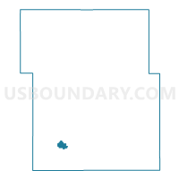
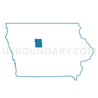
GOWRIE Voting District, Webster County, Iowa
About
Outline

Summary
| Unique Area Identifier | 583706 |
| Name | GOWRIE Voting District |
| County | Webster County |
| State | Iowa |
| Area (square miles) | 1.45 |
| Land Area (square miles) | 1.45 |
| Water Area (square miles) | 0.00 |
| % of Land Area | 100.00 |
| % of Water Area | 0.00 |
| Latitude of the Internal Point | 42.27783860 |
| Longtitude of the Internal Point | -94.28971670 |
Maps

Graphs
Select a template below for downloading or customizing gragh for GOWRIE Voting District, Webster County, Iowa


Neighbors
Neighoring Voting District (by Name) Neighboring Voting District on the Map
- GOWRIE TWP W/O GOWRIE Voting District, Webster County, IA
- LOST GROVE TWP W/O GOWRIE & HARCOURT Voting District, Webster County, IA